InSAR is a satellite-based radar measurement technique able to survey large areas of the earth's surface and provide, at a minimum, monthly updates on ground deformation (McColpin, 20092009 - G. R. McColpinSurface deformation monitoring as a cost effective MMV methodsee more). The user only has to ask for a satellite to be tasked to a project area and purchase a data subscription to begin acquisition. Images normally cover 2,500 to 10,000 square kilometres. Searches can be easily done for historical baseline data, which may exist in the industry's extensive archives.
InSAR works by taking readings at regular intervals and comparing changes from month to month (see Fig. 2-8). Accuracy with just two scenes is in the centimetre range but millimetre accuracy can be achieved by stacking many months of data to eliminate atmospheric errors. Accuracy can also be improved through integration of DGPS and tiltmeter data, which can provide finer resolution over smaller areas (McColpin, 20092009 - G. R. McColpinSurface deformation monitoring as a cost effective MMV methodsee more). Differences between scenes are usually represented as coloured bands with each band representing an interval of ground movement.
| 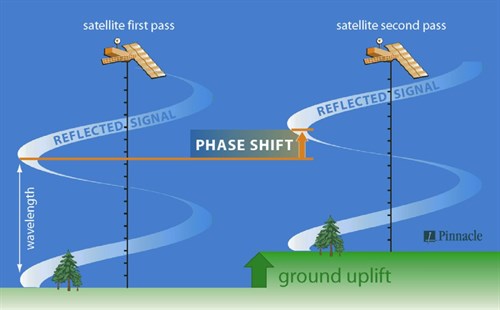 McColpin, 20092009 - G. R. McColpinSurface deformation monitoring as a cost effective MMV methodsee more)."> McColpin, 20092009 - G. R. McColpinSurface deformation monitoring as a cost effective MMV methodsee more).">
Fig. 2-8: Principle of the InSAR method (McColpin, 20092009 - G. R. McColpinSurface deformation monitoring as a cost effective MMV methodsee more). |
InSAR works best in areas with consistent radar reflections. Areas with dense vegetation can be problematic, as wellManmade hole drilled into the earth to produce liquids or gases, or to allow the injectionThe process of using pressure to force fluids down wells of fluids as areas with natural variations in the surface caused, e.g. by frost heave or wetting-drying cycles, which mask the changes that occur due to pressure changes (IPCCIntergovernmental Panel on Climate Change, 2005). Earthworks represent another type of "masking" effects in the survey area.
Results in the above-mentioned problematic areas can be improved by installation of simple sheet metal corner reflectors, which create a high surface-to-noise ratio. By properly placing and installing these reflectors, generation of accurate reflections from month to month can be ensured (McColpin, 20092009 - G. R. McColpinSurface deformation monitoring as a cost effective MMV methodsee more). Another deficiency of standard InSAR measurements is that the method is unable to resolve the horizontal and vertical components of the recorded motion.
The technology is now being used in various modifications, of which in particular the DInSAR (Differential Interferometric Synthetic Aperture Radar) and PSInSAR (Permanent Scatterers) techniques have provided interesting results. DInSAR is based on pixel-by-pixel computation of interferometric phase using two satellite radar acquisitions: such differential phase is a measurement of what has changed in the time interval between the two satellite acquisitions (ERS: 35 days, Envisat: 35 days, Radarsat: 24 days and TerraSAR-X: 11 days). Apparent phase variations between two satellite images can be caused by actual ground displacement or by atmospheric effects that delay electromagnetic wave propagation. An example of DInSAR results is shown in Fig. 2-9.
| 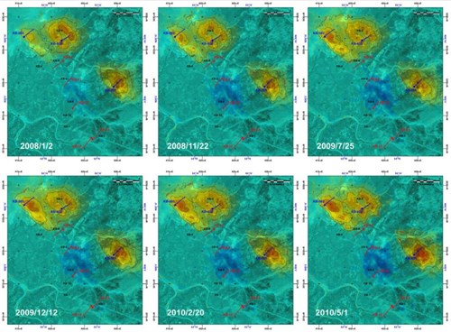
Fig. 2-9: DInSAR results from In Salah showing deformation time series with respect to July 31, 2004 for six selected dates. Areas around the KB-501 and KB503 Wells are swelling up, while KB-502 is slightly subsiding. Contour interval is 5 mm (Onuma et al., 20112011 - T. Onuma, K. Okada and A. OtsuboTime series analysis of surface deformation related with CO2 injection by satellite-borne SAR interferometry at In Salah, Algeriasee more). |
The PSInSARTM technique uses a temporally complete set of SAR scenes obtained over an identical target area. The approach is based on a few basic observations: atmospheric artefacts show strong spatial correlation within individual SAR acquisitions but are uncorrelated in time and, conversely, target motion is usually strongly correlated in time, exhibiting varying degrees of spatial correlation depending on the type of deformation (e.g. subsidence due to water pumping, fault(geology) A surface at which strata are no longer continuous, but are found displaced displacements, localised sliding areas, collapsing buildings, etc.). In order to separate these phenomena, atmospheric effects are estimated and then removed by combining data from long time series of SAR images (such as those available in the ESA-ERS archive), which were acquired from late 1991.
In order to improve the accuracy of ground displacement estimations, only scatterers minimally affected by temporal and geometrical decorrelations are selected for processing (Ferretti et al., 20012001 - Alessandro Ferretti, Claudio Prati, Fabio RoccaPermanent scatterers in SAR interferometrysee more; Tamburini et al., 20102010 - Andrea Tamburini, Giacomo Falorni, Fabrizio Novali, Alfio Fumagalli, Alessandro FerrettiAdvances in reservoir monitoring using satellite radar sensorssee more). The PSInSARTM technique was introduced by the Politecnico di Milano (POLIMI) in the late nineties, and later improved by Tele-Rilevamento Europa (TRE). Its main advantages are the extension of area that can be monitored (up to thousands of square kilometres) and the accuracy of the obtained measurements (deformation rates accurate to millimetres/year).
Due to the geographical characteristics of the area, the In Salah CO2Carbon dioxide storage(CO2Carbon dioxide) A process for retaining captured CO2Carbon dioxide, so that it does not reach the atmosphereThe layer of gases surrounding the earth; the gases are mainly nitrogen (78%) and oxygen (around 21%) site in the Algerian part of the Sahara desert has become a field laboratory for testing of the InSAR technology for the purposes of CO2Carbon dioxide storage(CO2Carbon dioxide) A process for retaining captured CO2Carbon dioxide, so that it does not reach the atmosphereThe layer of gases surrounding the earth; the gases are mainly nitrogen (78%) and oxygen (around 21%) monitoringMeasurement and surveillance activities necessary for ensuring safe and reliable operation of a CGS project (storage integrity), and for estimating emission reductions. Results of several independently working groups have been published (e.g. ùOnuma et al., 2011; Vasco et al., 20102010 - DW Vasco, Alessio Rucci, Alessandro Ferretti, Fabrizio Novali, RC Bissell, PS Ringrose, AS Mathieson, IW WrightSatellite‐based measurements of surface deformation reveal fluid flow associated with the geological storage of carbon dioxidesee more). Moreover, the InSAR data were used for geomechanical, reservoirA subsurface body of rock with sufficient porosityMeasure for the amount of pore spaceSpace between rock or sediment grains that can contain fluids in a rock and permeabilityAbility to flow or transmit fluids through a porous solid such as rock to store and transmit fluids and fluid-flow analyses of processes occurring within the reservoirA subsurface body of rock with sufficient porosityMeasure for the amount of pore spaceSpace between rock or sediment grains that can contain fluids in a rock and permeabilityAbility to flow or transmit fluids through a porous solid such as rock to store and transmit fluids during CO2Carbon dioxide injectionThe process of using pressure to force fluids down wells (e.g. Rutqvist et al., 20102010 - Jonny Rutqvist, Donald W. Vasco, Larry MyerCoupled reservoir-geomechanical analysis of CO2 injection and ground deformations at In Salah, Algeriasee more; Morris et al., 20112011 - Joseph P. Morris, Yue Hao, William Foxall, Walt McNabA study of injection-induced mechanical deformation at the In Salah CO2 storage projectsee more; Shi et al., 20122012 - Ji-Quan Shi, Caglar Sinayuc, Sevket Durucan, Anna KorreAssessment of carbon dioxide plume behaviour within the storage reservoir and the lower caprock around the KB-502 injection well at In Salahsee more) or CO2Carbon dioxide distribution simulations (Cavanagh and Ringrose, 20112011 - Andrew Cavanagh, Philip RingroseSimulation of CO2 distribution at the In Salah storage site using high-resolution field-scale modelssee more).
Surface deformation monitoringMeasurement and surveillance activities necessary for ensuring safe and reliable operation of a CGS project (storage integrity), and for estimating emission reductions techniques are generally applicable only onshore. The only exception is tiltmeters: underwater tiltmeters are commonly deployed to monitor sea bottom-based structures. They have not been, however, deployed in larger arrays yet. The issues connected with the use of underwater tiltmeters embrace on-site deployment, power supply and transfer of measured data. Nevertheless, this method could prove to be cost-effective in future compared to other offshore monitoringMeasurement and surveillance activities necessary for ensuring safe and reliable operation of a CGS project (storage integrity), and for estimating emission reductions techniques (McColpin, 20092009 - G. R. McColpinSurface deformation monitoring as a cost effective MMV methodsee more).