DGPS is a monitoringMeasurement and surveillance activities necessary for ensuring safe and reliable operation of a CGS project (storage integrity), and for estimating emission reductions technique which uses a minimum of two GPS receivers and sophisticated Kalman filtering to achieve millimetre level measurements of horizontal and vertical motion. One receiver is usually located in an area that is expected to be relatively stable and subsequent receivers are located in regions of interest where motion is expected. By using the two stations, atmospheric variations can be identified and backed out, resulting in the desired millimetre level accuracy (McColpin, 20092009 - G. R. McColpinSurface deformation monitoring as a cost effective MMV methodsee more). The principle of the method is shown in Fig. 2-6.
DGPS readings, similarly to InSAR (see Section 2.2.3), can be influenced by vegetation or interference caused by buildings, fences and any other objects which might reflect or delay the GPS signal. Evaluating site conditions is critical for proper receiver placement and good-quality results. DGPS is a mature technology used for monitoringMeasurement and surveillance activities necessary for ensuring safe and reliable operation of a CGS project (storage integrity), and for estimating emission reductions of surface deformations in a broad spectrum of applications, starting from seismology, earth crust studies and volcanology, through oil and gas industry operations to landslide stability and engineering applications.
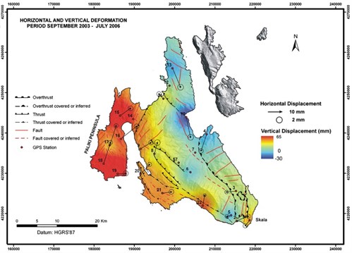
An example of DGPS results from a project focused on crustal deformation is shown in Fig. 2-7. This project was focused on monitoringMeasurement and surveillance activities necessary for ensuring safe and reliable operation of a CGS project (storage integrity), and for estimating emission reductions of surface movements in the seismically active area of the Central Ionian Islands. In the particular case of the Cephallonia island, a local GPS network was established in 2001, and 4 repeat surveys were carried out in 2001 - 2006. Both horizontal and vertical movements were observed. The DGPS results for the whole observational period show horizontal displacements between 10 and 35 mm and a clock-wise rotation of the whole island. Vertical displacements range from 65 mm uplift in the western part of the island to 30 mm subsidence in the East. The results are in agreement with InSAR data (see the text below for technical details of this method) gathered in the same area within several campaigns in 1995 - 2005 (Lagios et al., 20072007 - E. Lagios, V. Sakkas, P. Papadimitriou, I. Parcharidis, B.N. Damiata, K. Chousianitis, S. VassilopoulouCrustal deformation in the Central Ionian Islands (Greece): Results from DGPS and DInSAR analyses (1995–2006)see more).
Due to the high hardware cost, DGPS stations are normally used to supplement tiltmeter arrays and InSAR data acquisition. They are critical for providing a long-term and stable ground truth reference (McColpin, 20092009 - G. R. McColpinSurface deformation monitoring as a cost effective MMV methodsee more). At In Salah, DGPS has recently been used as one of the monitoringMeasurement and surveillance activities necessary for ensuring safe and reliable operation of a CGS project (storage integrity), and for estimating emission reductions technologies with a similar main purpose of deployment to tiltmeters, i.e. to calibrate the satellite (InSAR) data (Mathieson et al., 20112011 - A. Mathieson, J. Midgely, I. Wright, N. Saoula and P. RingroseIn Salah CO2 Storage JIP: CO2 sequestration monitoring and verification technologies applied at Krechba, Algeriasee more).
| 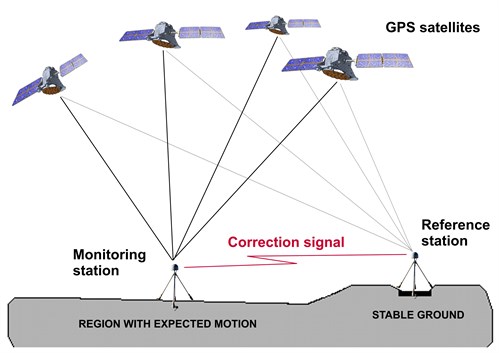
Fig. 2-6: Operational principle of DGPS. |
|  Lagios et al., 20072007 - E. Lagios, V. Sakkas, P. Papadimitriou, I. Parcharidis, B.N. Damiata, K. Chousianitis, S. VassilopoulouCrustal deformation in the Central Ionian Islands (Greece): Results from DGPS and DInSAR analyses (1995–2006)see more)."> Lagios et al., 20072007 - E. Lagios, V. Sakkas, P. Papadimitriou, I. Parcharidis, B.N. Damiata, K. Chousianitis, S. VassilopoulouCrustal deformation in the Central Ionian Islands (Greece): Results from DGPS and DInSAR analyses (1995–2006)see more).">
Fig. 2-7: Results of DGPS measurements of crustal deformations at the Cephallonia Island, Central Ionian Islands, Greece (Lagios et al., 20072007 - E. Lagios, V. Sakkas, P. Papadimitriou, I. Parcharidis, B.N. Damiata, K. Chousianitis, S. VassilopoulouCrustal deformation in the Central Ionian Islands (Greece): Results from DGPS and DInSAR analyses (1995–2006)see more). |